Integrated Modeling
An Integrated Hydroclimatic Model of the Truckee-Carson River System, Western US
Downloadable research poster (PDF)
Enhancing International Transferability of Collaborative Modeling Poster (PDF)
Why do we need an integrated hydroclimatic model?
The Truckee-Carson River System is a snow-fed arid land watershed in the western US where a warming climate threatens snowpack accumulation and subsequent timing and availability of water supply, challenging the system’s capacity to satisfy routine water demand. To forward climate science research and effectively support climate adaptation strategies, an integrated hydroclimatic model is necessary that incorporates stakeholder input, realistic hydrologic conditions, and current operating policy. An interdisciplinary team of scientists has integrated a suite of hydroclimatic models to examine the potential distribution, circulation and partitioning of water resources under extreme climate scenarios, such as extended drought.
How do stakeholders contribute to the development of an integrated hydroclimatic model?
Model inputs feature results from structured interviews conducted in 2015 with representatives of 66 organizations with water management responsibilities or interests in the river system. These interviews provided spatially and temporally explicit measures for drought threshold indicators used to craft plausible climate scenarios. In addition, these interviews informed hydrologic modelers about how to share results with a Stakeholder Affiliate Group comprised of representatives of 12 key water management organizations with particularly “high stakes” in changes to the system.
Integration occurs through:
– Incorporating stakeholder input into climate scenarios;
– Feeding climate scenario data into hydrologic models; and
– Coupling hydrologic models with operations models.
The result of this integration links together stakeholder input, climate scenarios, and a suite of models to better assess and enhance climate resiliency.
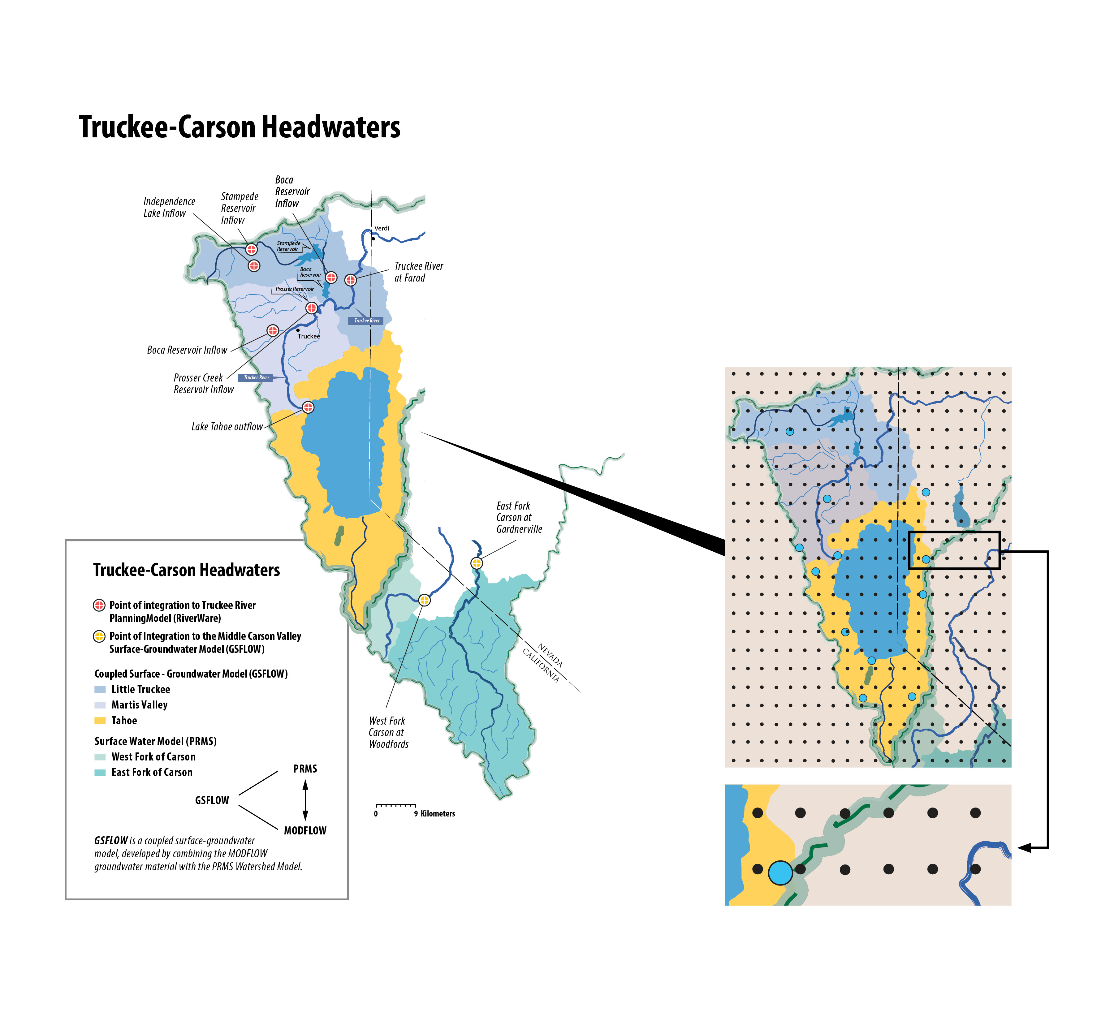
Truckee-Carson Headwaters
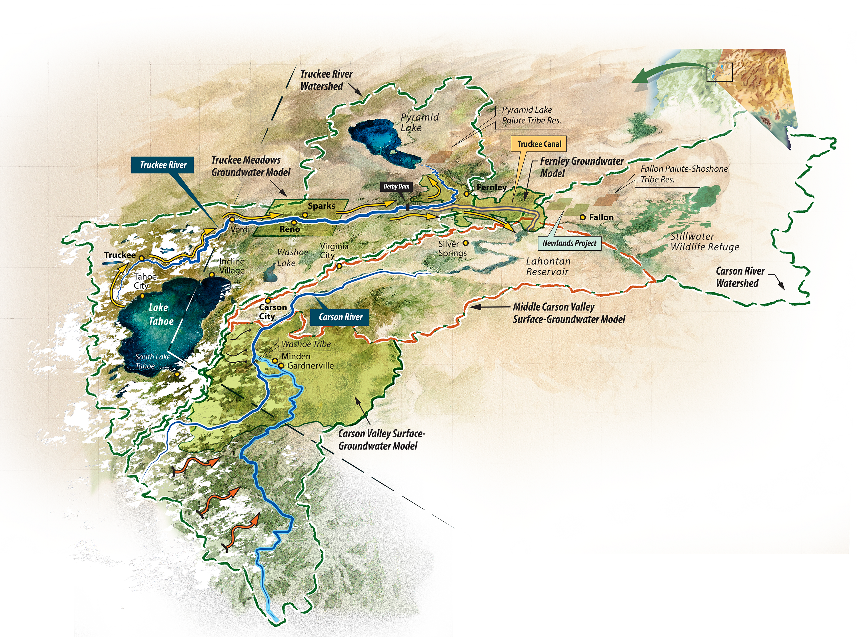
The Truckee-Carson River System originates in the Sierra Nevada and relies on winter snowpack and spring runoff as the primary sources of water. The Upper Truckee Watershed consists of three sub-basins: the Little Truckee, Martis Valley and Lake Tahoe. The Upper Carson Watershed consists of two sub-basins: West Fork of the Carson River and the East Fork of the Carson River. High resolution coupled surface-groundwater models (GSFLOW) have been developed for the Truckee sub-basins, and surface runoff models (PRMS) have been developed for the Carson sub-basins. Points of integration indicate locations where hydrologic flows are passed to models downstream that share a common model boundary, or have a common input-output parameter. The hydrologic models in the Truckee headwaters provide data for the Truckee Planning Model (RiverWare) at seven locations. The Carson headwaters provide data for the Carson Valley Surface-Groundwater Model (GSFLOW) at two locations.
The Upper Truckee and Carson Watershed models are calibrated using streamflow data. Historical data from climate stations in the basins (i.e., SNOTEL sites) serve as inputs to run the models. The 13-year drought scenario provides a daily time series of precipitation, maximum and minimum temperatures at 4 km gridded resolution (i.e., black points). To simulate this scenario in the TCRS, these data points are matched to existing weather monitoring stations (i.e., blue points) and then fed directly into hydrologic models. Daily climate station data are then interpolated to the finer grid resolution of the hydrologic models using the monthly-average 300 meter PRISM spatial climate data.
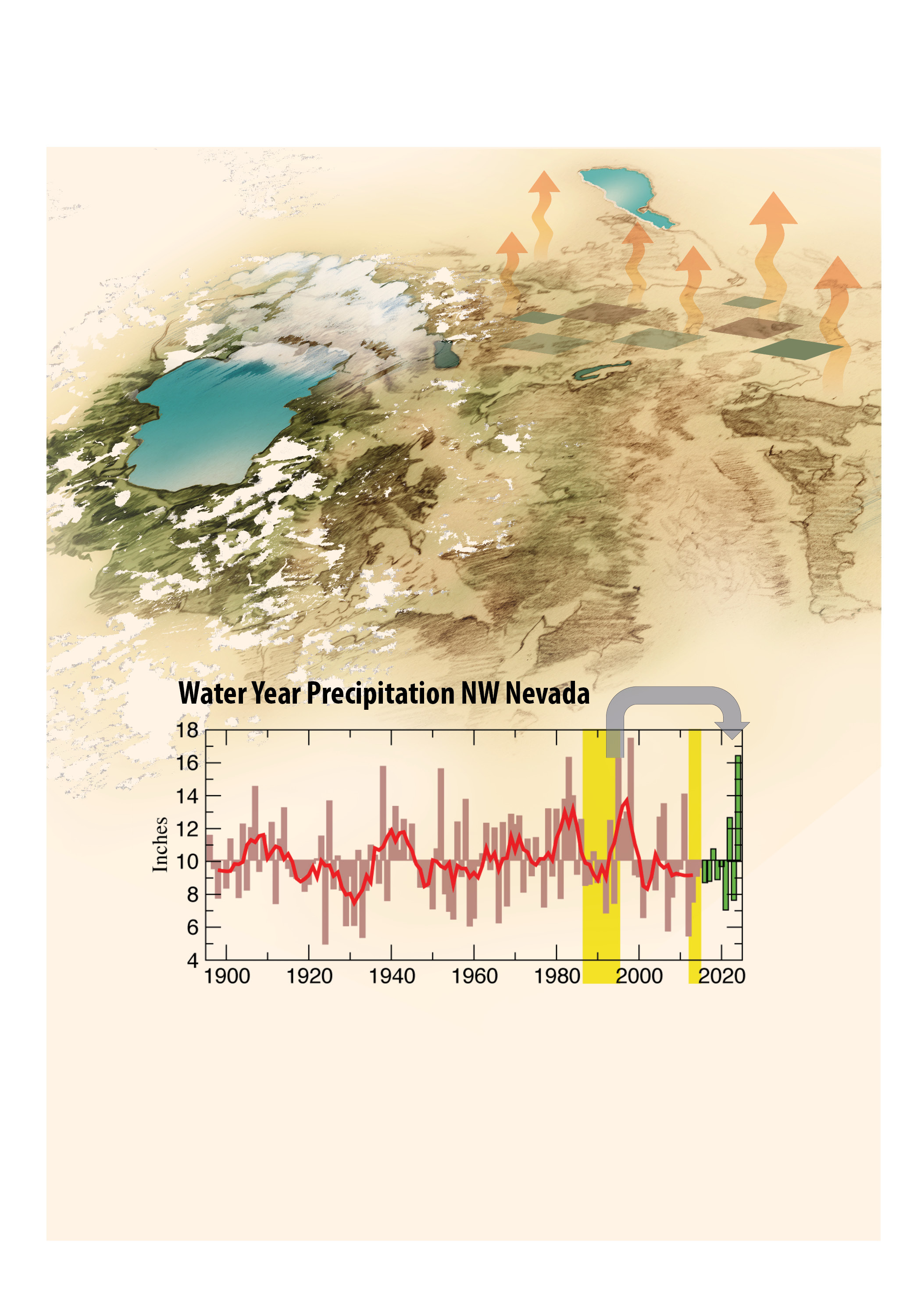
A Prolonged Drought Scenario
A majority of stakeholders described the current drought as one of the worst imaginable. The resulting 13-year drought scenario links conditions from 1987-1994 drought to the end of the current 2012-2015 drought. Water for the Seasons models two versions of this scenario: 1a) Temperature for 1987-95 period is nudged upward to reflect present-day conditions. Data from 2012-2015 will not be altered; 1b) All temperatures will be adjusted for future warming according to projections for 2051-2070.
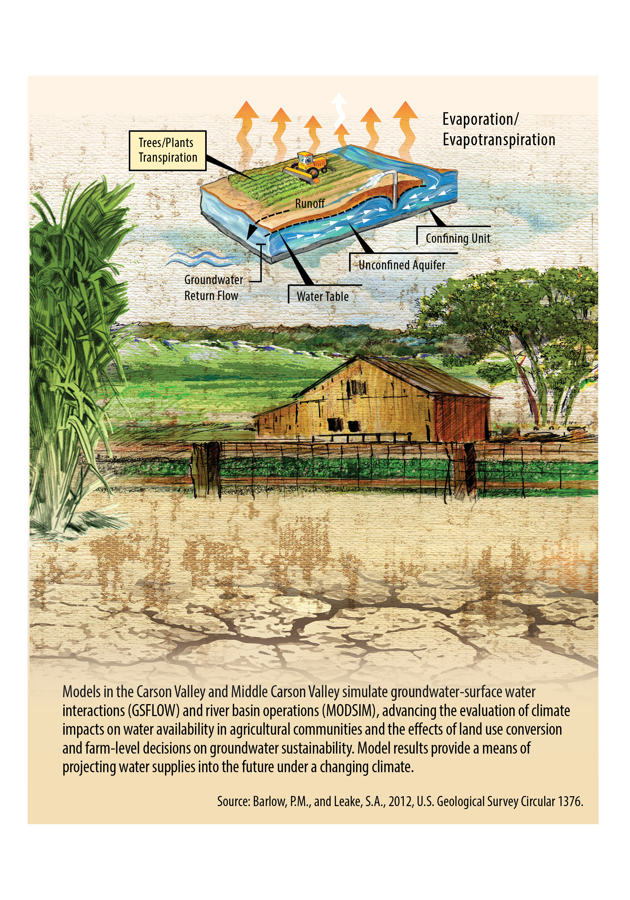
Carson Valley Agriculture
Models in the Carson Valley and Middle Carson Valley simulate groundwater-surface water interactions (GSFLOW) and river basin operations (MODSIM), advancing the evaluation of climate impacts on water availability in agricultural communities and the effects of land use conversion and farm-level decisions on groundwater sustainability. Model results provide a means of projecting water supplies into the future under a changing climate.
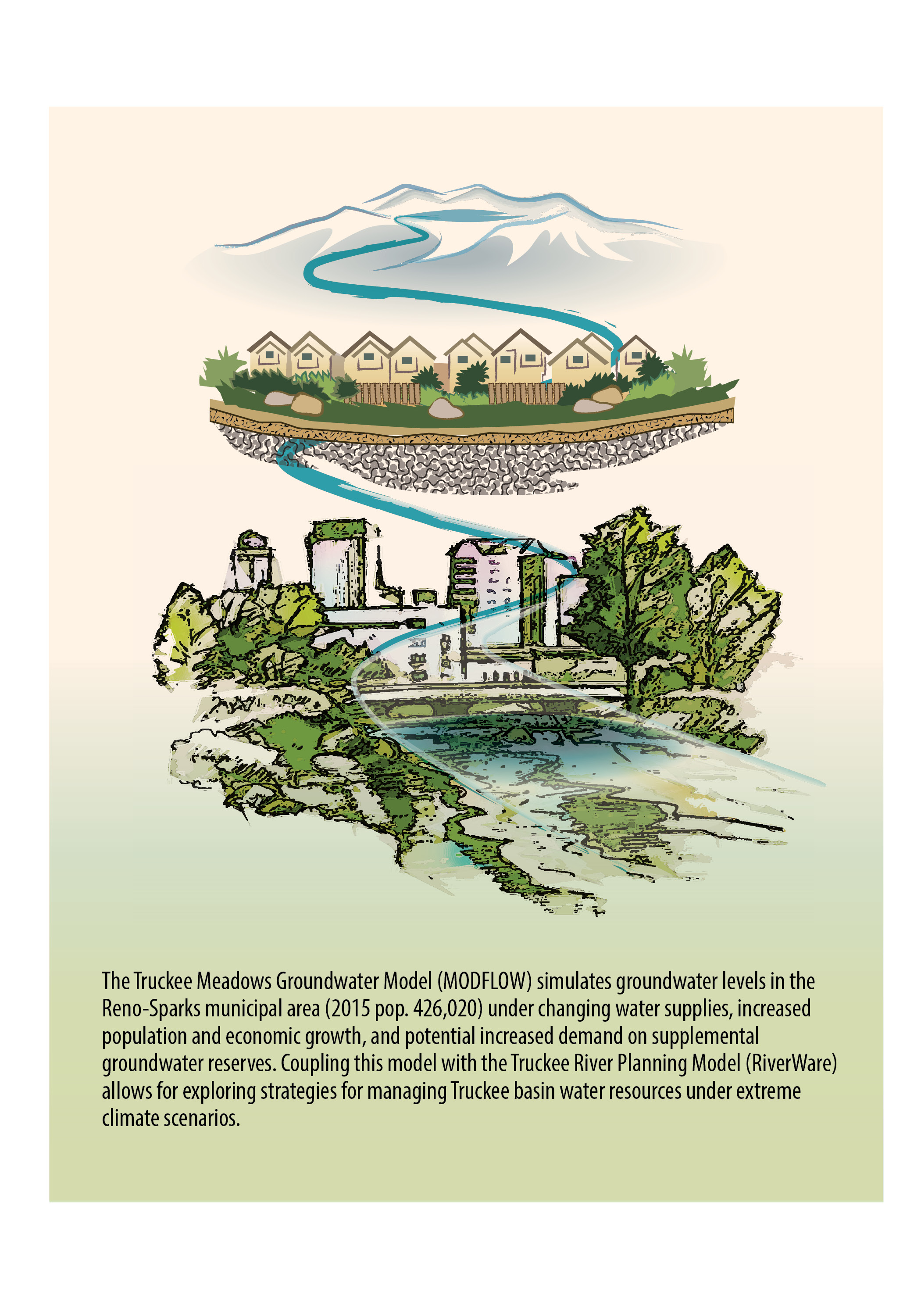
Truckee Meadows Municipal and Industrial Use
The Truckee Meadows Groundwater Model (MODFLOW) simulates groundwater levels in the Reno-Sparks municipal area (2015 pop. 426,020) under changing water supplies, increased population and economic growth, and potential increased demand on supplemental groundwater reserves. Coupling this model with the Truckee River Planning Model (RiverWare) allows for exploring strategies for managing Truckee basin water resources under extreme climate scenarios.
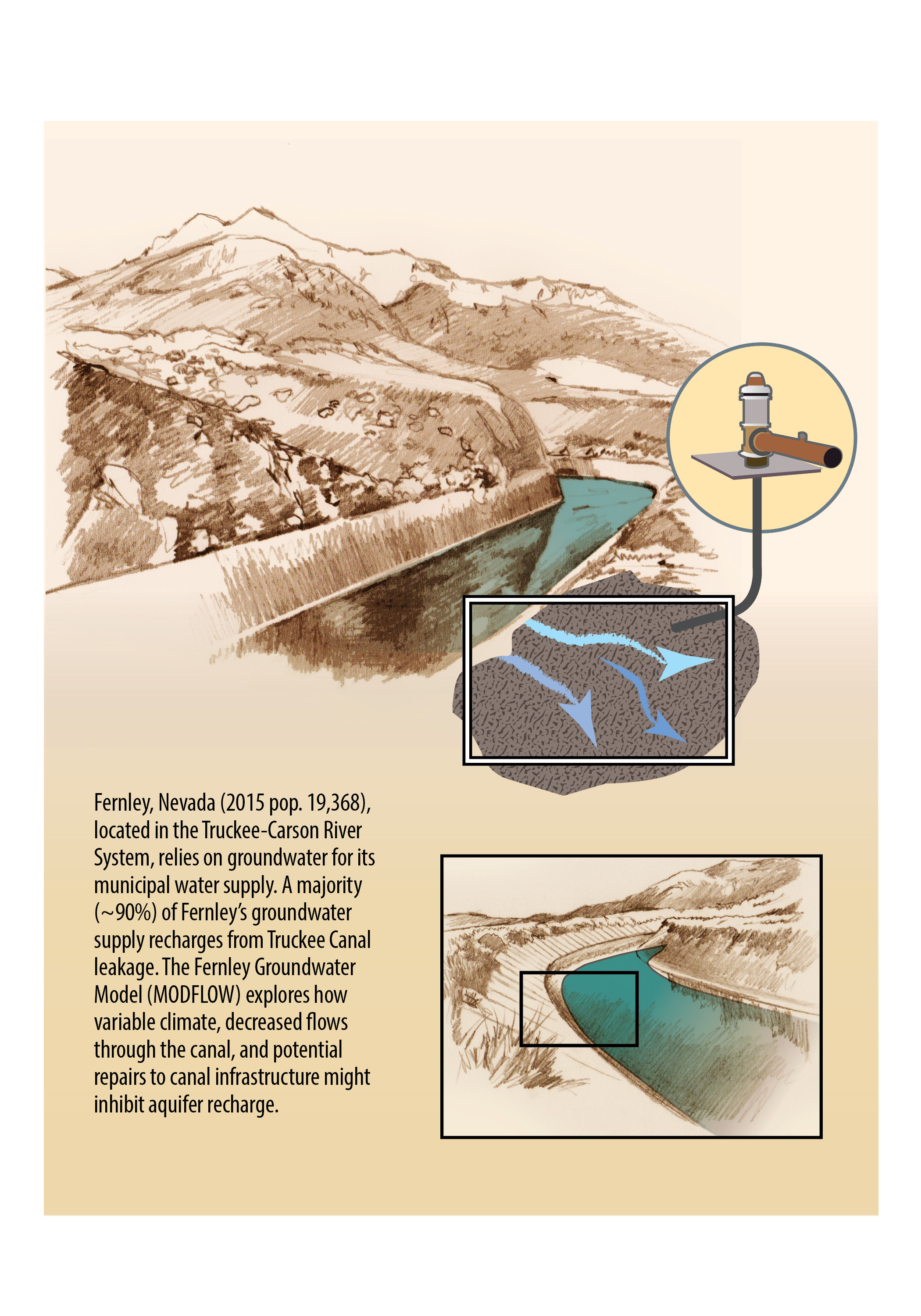
Fernley Groundwater Supply
Fernley, Nevada (2015 pop. 19,368), located in the Truckee-Carson River System, relies on groundwater for its municipal water supply. A majority (~90%) of Fernley’s groundwater supply recharges from Truckee Canal leakage. The Fernley Groundwater Model (MODFLOW) explores how variable climate, decreased flows through the canal, and potential canal infrastructure repair might inhibit aquifer recharge.
Authors: Kelley Sterle1, Greg Pohll2, Mike Dettinger3, Seshadri Rajagopal2, Shane Coors4, Linnet Jose4, Rich Niswonger3, Eric Morway3, Wesley Kitlasten3, Justin Huntington2, Murphy Gardner3, Maureen McCarthy1, Loretta Singletary1, Karen Simpson1, Derek Kauneckis5
Affiliations:
1 University of Nevada, Reno;
2 Desert Research Institute;
3 United States Geological Survey;
4 Precision Water Resources Engineering;
5 Ohio University.